- Services

Getting to know us
- Industries
Recent case study:
Oracle EBS Cloud Deployment
Consolidating and Migrating assets into Oracle Cloud Infrastructure.
.png?width=250&name=stonewater-logo%20(1).png)
Most Visited Pages
-
- Resources
DSP-Explorer acquires leading Oracle Applications Managed Services Provider, Claremont, to further extend its data management capabilities.

Resources
- Contact us
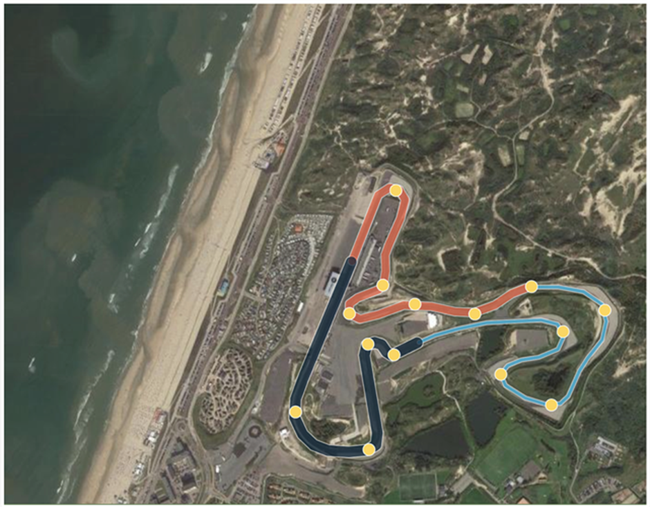
How Oracle and Red Bull developed an Interactive F1 Racetrack
Contents
It’s race week and the start of the 2023 F1 season! In this blog, we will explore how current driver and constructor champions, Oracle Red Bull Racing, developed an interactive map of a racetrack with GeoJSON in Oracle Analytics Cloud. We discuss the role of different Oracle tools and how they were utilised to build the interactive map.
Building an interactive F1 racetrack
Oracle and Red Bull Racing developed an interactive map of an F1 racetrack, which allows fans to experience a virtual tour of the track and gain insights into the car's performance and telemetry data.
The interactive map is built using Oracle Cloud Infrastructure. It incorporates a wide range of data sources, such as GPS, tire temperature, and car speed, to provide a comprehensive view of the racetrack. Users can view the track from different angles and zoom in to see detailed information about specific sections of the track.
The map also provides insights into the car's performance and telemetry data, such as how much fuel is being used, the car's top speed, and how much energy is being regenerated during braking. Users can view real-time data from the car's sensors, allowing them to see how the car performs during a race.
Click this link if you would like to explore the Oracle LiveLabs session for yourself - https://apexapps.oracle.com/pls/apex/r/dbpm/livelabs/run-workshop?p210_wid=896&p210_wec=&session=104015873923836
Spatial analytics and geospatial technologies
Oracle Analytics Spatial is a component of the Oracle Analytics platform that allows users to incorporate location-based data into their analytics and reporting workflows. It enables users to visualise, analyse, and map data that includes a spatial or location-based element.
Oracle’s spatial and location platform delivers enterprise performance, security, and scalability to run the most challenging applications in Oracle Cloud Infrastructure and on-premises.
Key features of Oracle Analytics Spatial
Comprehensive geospatial data models:
- 2D spatial data
- 3D Point Cloud data and Light Detection and Ranging (LiDAR)
- Raster data
- Network data
- Topology data
- Streaming point data
Self-service, no-code mapping tool:
- Spatial Studio application
- Analyst support
- Developer Support
- Data integration and enrichment
Development tools and geospatial frameworks:
- Popular language and frameworks
- Oracle developer tools
- Enrich data
- Contact tracing APIs
- Support GIS and open-source tools
Readily deployable service:
- Map visualisation of geographic data
- Geocoding and reverse geocoding
- Routine engine
- Open Geospatial Consortium web services
Enterprise-level scalability and security:
- Scalability and performance
- Secure spatial data reliability
- Autonomous capabilities
- Align with global standards
Capabilities of Oracle Database Spatial
Oracle Database Spatial has similar features to Oracle Analytics Spatial. It’s an extension of the Oracle Database that supports geographic and location-based data, which enables the storage, indexing, and querying of spatial data, such as maps, GPS coordinates, and geospatial data.
Key functionalities of Oracle Database Spatial:
- Spatial data types: Oracle Database Spatial includes support for spatial data types, such as point, line, and polygon, which can be used to represent geographic features and locations.
- Spatial indexing: Oracle Database Spatial uses spatial indexing techniques to optimise the performance of spatial queries. These indexes enable fast retrieval of spatial data based on location and proximity.
- Spatial analysis functions: Oracle Database Spatial includes a set of functions that allow users to perform spatial analysis operations, such as distance calculations, buffer operations, and intersection tests.
- Map visualisation: Oracle Database Spatial includes support for creating maps and visualising spatial data using tools like Oracle MapViewer.
- Integration with other Oracle products: Oracle Database Spatial integrates with other Oracle products, such as Oracle Business Intelligence Enterprise Edition (OBIEE), Oracle Spatial Studio, and Oracle Application Express (APEX).
The interactive map provides an engaging and informative experience for F1 fans, allowing them to gain a deeper understanding of the sport and the performance of the Red Bull Racing team. Let's hope for more of the same from the Oracle Red Bull Racing team this year and retain the drivers and constructors’ championships.
Want to make more data-driven decisions? Read more about our data science services.